

Part One: The Discovery
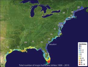 The map you see here identifies a one billion dollar opportunity. It was published by the National Hurricane Center in 2010 to illustrate the projected frequency of hurricanes. But it shows much more than that. Notice where the coastline is edged in deep blue. That color band literally identifies the best fall weather in the South.
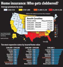
Yes, the best fall weather, that has a relatively low risk for hurricanes, extends from Charleston to Jacksonville, Florida. And that knowledge alone raises two questions: Why is our homeowner insurance so high if our coastal risk is so low? And if we have the best fall weather in the South, why does our county tourism drop 65% from summer to fall?
I will answer those questions in the next few months. Furthermore, I will promise you one thing: the answers may shock you. My quest to answer these questions was sparked by simple curiosity. As a businessman, I know that many opportunities are spotted by witnessing events that simply make no sense. Or we notice problems that bother us. Real magic often happens when we turn curiosity into problem solving. And that magic often translates into new sales and revenue. It also leads us to add new employees to the work force.
You need to know what motivated me to spend three years digging behind our coastal risk for fall hurricanes. It wasn’t that I find hurricanes or homeowner insurance terribly interesting. Frankly, I would rather be working on my farm in Bamburg County or shrimping in the nearest tidal creek. But my initial curiosity led me to a simple discovery that has the potential to bring 2,000 to 4,000 people back to work. And if I can do anything to bring one or two of our families back to work, then it will have been time well spent.
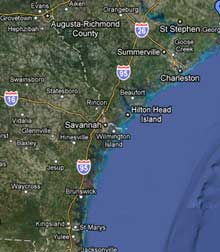
I moved to Beaufort in 2000. I’ll never forget one of the first dinner parties my wife and I attended in October of that year. The TV networks had just reported the track of a westward-headed hurricane in the mid-Atlantic. The latest report had it heading straight toward Beaufort County. You know how the conversation went. The couple who just moved here from New Jersey asked where they could buy plywood for the windows. The husband of the couple who had lived here forever informed us that the Great Hurricane of 1893 literally covered the county in water… and thousands died. There was no conclusion to this party discussion. It just went around and around. If there was a TV network conclusion, it was this: If you live along the coast of any Southern coastal state, you are probably living in a state that is a magnet for hurricanes.
After hearing this conversation for eight years, something did not make sense. “Why are we guessing?” I wondered. If the National Hurricane Center has a record of 120 years of coastal hurricane strikes, they must have a projection as to when the next major hurricane will hit our coast. And if the insurance industry has to set rates for homeowner insurance, they certainly must have projections to set those rates. And if they have those rates, they certainly must know whether our coast is rated as having a ‘high hurricane risk’, ‘above average,’ or ‘average’ hurricane risk. (http://videospelautomater.com/blog/enarmad-bandit.html)
My curiosity started to churn. I called the National Hurricane Center and asked to speak to a hurricane specialist. What I did not know is that the NHC has dozens of hurricane experts; but they pride themselves on being scientists, not customer service representatives. They really do not want to talk with you and me. I soon discovered that unless you know hurricane meteorology, you will never talk with one of them. So, I went back to the books and learned as much as I could about hurricanes.
After six months of book learning, I called the senior supervisor of the NHC’s hurricane specialists. I got his attention. He knew that I could talk “hurricane.” Within a few minutes I made my case, “There must be some estimate of the fall hurricane risk for the coast between Charleston and Savannah. You must have the data. I would like to see your risk assessment for the major hurricanes, Classes 3,4, and 5 for southern South Carolina.” I was not surprised by his answer, “Yes, we have them. I will forward them to you.”
There are five categories of hurricanes. The National Hurricane Center, and the insurance industry, pays special attention to the MAJOR hurricanes, categories 3,4,and 5. As the attached chart shows, they are the ones that do the most damage. Thus, the more frequent that an insurance company believes that a major hurricane will hit our shores, the higher that they will project future storm costs. Simply put that means higher homeowner insurance premiums.

The real eye-opener came in 2009. A NHC hurricane specialist sent me a chart that estimated the number of years it would take for a major hurricane to hit Beaufort County. Their projections showed that the least risky major hurricane, a Class 3, would statistically hit us in 79 years . . . a more damaging Class 4 hurricane would hit us in 210 years; and the most damaging Class 5 would probably hit us in 500 plus years. For a guy who lived 21 years in South Dakota and saw one or two tornadoes every summer, I was shocked. It did not seem like much risk. So, I contacted four of the Center’s hurricane specialists and asked this question: ” I have the NHC’s projection of future hurricanes off of our coast. In three words, or less, how would you describe our risk for fall hurricanes?” They all said exactly the same three words: RELATIVELY LOW RISK. Beaufort County has a relatively low risk for future hurricanes.
That was really not enough for me. I wanted to know why hurricanes tend not to visit the shores of Southern South Carolina? Was it because our coastline is concave, and that we are really 150 miles inland from the natural Atlantic coast?
Here’s the answer that the NHC hurricane specialists gave me. When a hurricane enters the Caribbean from Africa, it will either fork into the Gulf or turn northward and follow the Atlantic coastline. Most of the hurricanes will go into the Gulf because the Gulf is warmer in the fall, and hurricanes like warm water. But some will go north. And a hurricane that is traveling north can arc inland as well as seaward. But why do most of the storms that come close to South Carolina arc out to sea? One big reason. There is a low pressure front along our coast throughout the year. As the fall approaches, the mid-latitude jet stream moves southward out of Canada. As soon as this cold air front drops down into the United States, it touches the warm low pressure front along our coast and creates a separate weather system that blows 75% of all hurricanes out to sea. For the few times that this new weather system is not created, a hurricane can move inward. That storm can arch to the left . . . inward. However, because our coast is approximately 150 miles inland from the “normal” U.S. coast, those few hurricanes will hit the coast in North Carolina or sometimes in northern South Carolina. This is why hurricanes tend to stay away the coastline from Charleston to Jacksonville, Florida.

This sounded incredible. The National Hurricane Center believes that our coast has a “relatively low risk” for fall hurricanes, yet all we hear from the national press each fall is that “it can happen at any time.” That was the title of the Weather Channel’s special last year on hurricanes: “It can happen at any time.” This is a message that our risk is high, not low, for fall hurricanes. But the behind-the-scenes data supports the claim that our risk is relatively low. The following chart tells the story. 
In over 150 years, only eight hurricanes have hit Beaufort County, and only one of them was a major hurricane: Hurricane Gracie in 1960. The damaging Great Sea Island Hurricane of 1893 is believed to have been a Class 2 hurricane by the time it hit Beaufort County. Dr. Christopher Landsea, who heads the NHC Risk Assessment Program, told me it’s very possible that less than eight hurricanes probably hit our county. He makes this case: The NHC counts a hurricane “hit” as any time a hurricane’s center is within 58 miles of our coast. However, he said, if they were to measure the hurricane’s wind speed at the end of its 58 mile reach, the wind speed will often be below hurricane strength. It is beginning to look as if southern South Carolina has the best fall weather in the South.
Let me emphasize one point. I am not saying that we should lower our guard in preparing for the next hurricane. In fact, I believe just the opposite. We need to do everything we can to build better hurricane resistant homes. We need to strengthen our support for the county’s very effective Emergency Planning Department. But let’s do it like a cruise ship company would. Let’s make our preparation so strong that when our friends and family visit us, they have great confidence that we are prepared.
What we do need to check is this: If we now know that our coastal risk is “relatively low,” have the insurance companies set rates that reflect that lower risk? And if we know that our coast has the best weather in the South, are we sending that message to those who could be our future fall visitors?
Next Issue
There are those who doubt the claim that our coastline has a “relatively low risk” for fall hurricanes. They doubt it until they hear that top management of a major insurance company confirm it. And they doubt it until a “deep throat” within the insurance industry comes forward and says, “yes, it’s true.”
Daryl Ferguson has lived in Beaufort Country since 2000. He is the past President of Citizen’s Utilities, America’s largest multi utility, and former Chairman of the Board of Hungarian Telephone and Cable, its second largest communications company. Daryl holds a PH.D in Business and two patents.


